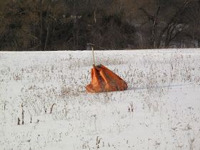
Geokinetics Inc. was in the neighborhood again this year preparing for the seismic survey. A helicopter was used to deliver packages of cables to the different locations on our hill. The following photo was taken from Steve's driveway as a package was delivered in his lawn next to Miner's pond.
After the delivery to Steve's lawn, the next package was delivered within 50 feet of where I was standing.
Photo of the cable package.
This blog will be used to communicate items of interest for the Joyce Road neighborhood. (Click on blog images for larger view)
31 January 2011
26 January 2011
Drilling Permits
We received copies of the drilling permit applications from Chesapeake today. In the stack of paper were maps showing the different well drilling locations. I was able to get the latitude/longitude for each of the wells and plot them on Google Map.
Here's the link to the Google Map of the JOYCE ROAD well locations.
I have also scanned maps for each of the six well permits and placed the maps on my web site.
I have obtained a copy of the Susquehanna River Basin Commission (SRBC) water permit for the JOYCE ROAD pad and Chesapeake states they are currently only permitting the JOYCE ROAD NW 5H well.
20 January 2011
Well Site Construction
Steven Clarke of Chesapeake was at the cabin property this morning with representatives from construction companies bidding on the construction of the JOYCE ROAD well pad and access road. I arrived on site as at least 15 trucks prepared to leave.
I asked Steve on a proposed schedule for the start of construction and he said it would depend on permits but his best guess is sometime in April.
06 January 2011
The stake is in the ground
With the cold weather there hasn't been too much to report from the Joyce Road neighborhood until today. While Mary was doing her daily walk to the cabin she met a team from Greenway Engineering leaving the property. The team from Greenway had just completed the surveying for the well pad on our property. As mentioned in an earlier blog posting, we had requested a different location for the well pad on our property and today the new location was staked out.
FYI - The well site name has been changed from EASTHILL to JOYCE ROAD (easier to find on a map).
The well location will be near the center of the property and farther from Joyce Road and neighborhood homes than the earlier location. The following image shows the placement of the well on our property (GPS = 41.845294, -76.330909) with the shaded area showing the well pad placement.
Google Map link