The abundance and diversity of the Spring and Summer flowers has narrowed as we enter Autumn. The many rain showers of September have produced a bumper crop of goldenrod flowers.
Some insects took advantage of the flowering goldenrod during the dry weather between the rain storms. While the number of wild honeybees has dropped off in the past years, they were large numbers of them working on the goldenrod.
While not as common as a honeybee, a blue wing wasp enjoyed the goldenrod.
The Monarch Butterfly (Danaus plexippus), which depends on the milkweed plant during its caterpillar stage, switches to flowers like the goldenrod in its adult (butterfly) stage.
Two honeybees and a bumble bee working on the goldenrod.
This blog will be used to communicate items of interest for the Joyce Road neighborhood. (Click on blog images for larger view)
30 September 2011
16 September 2011
Wilmot Pipeline
Earlier this week the activity was on the Wesauking pipeline route and today it was on the Wilmot pipeline route. A-1 Surveying was at the cabin property this afternoon placing new survey markers along the Wilmot pipeline route.
Later in the afternoon, Jeremy Freeland and Robert McCarty of Kleinfelder were at the cabin property to get GPS locations of wetlands along the Wilmot pipeline.
12 September 2011
Wesauking Pipeline Survey
A team from Navarro & Wright was in the neighborhood re-surveying the Wesauking pipeline route. This is yet again another survey of the same pipeline route that was surveyed in June by A-1 Surveying of Laceyville.
The survey team used the same GPS base station location near our cabin as did other survey teams.
New survey markers along Joyce Road near our barn.
The survey team used the same GPS base station location near our cabin as did other survey teams.
New survey markers along Joyce Road near our barn.
09 September 2011
Flood Damage
The water level of Wysox Creek was down enough that we were able to travel to Wysox for supplies this morning. Some of the clean-up along Route 187 had started but here are a few photos of what we saw.
Some of the flooded cars along Route 187 had been removed but this truck was located in a field just north of Myresburg.
This car was being removed from the flood water next to the Wysox Township Building along Route 187.
Shortly after the car was removed from the water these two people paddled by in a boat.
A boat paddles by the house near the Wysox Township building.
A little creek near Weaver's house, south of Gillette's Bridge, dumped rocks onto Route 187.
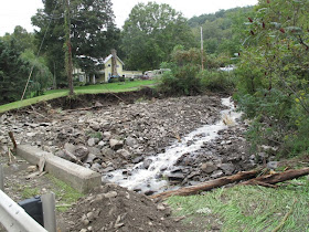
A view of Wysox Creek behind Weaver's Barn. Notice the stream bank which was washed out by the flooding. There used to be a road to the creek but now there is a 20 foot drop off.
Flood damage at the trailer court next to Route 187 south of Rome.
The small bridge at Elliott Road and North Rome Road is plugged full.
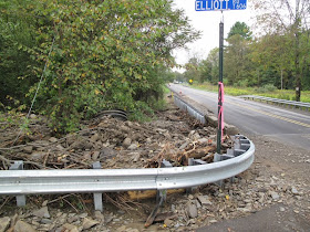
Flood trash at a bridge on North Rome Road.
Bridge damage on Battle Creek Road between Route 187 and Robinson Road.
Flood trash under the Route 187 bridge near Bob Wilmot's.
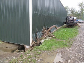
Damage at the old "sawmill" building along Route 187 north of Rome. Flooding from Wysox Creek pushed in the side of the building.
Wilmot's B&B next to Wysox Creek along Route 187.
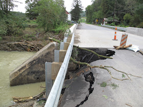
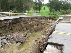
The bridge on Route 187 just north of Orwell Hill Road was washed out.
Washout at the north end of the bridge.
View from the creek.
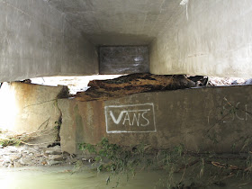
View of damage on the underside of the bridge. The north bridge abutment is broken in several places and the bridge deck is resting on a tree.
Some of the flooded cars along Route 187 had been removed but this truck was located in a field just north of Myresburg.
This car was being removed from the flood water next to the Wysox Township Building along Route 187.
Shortly after the car was removed from the water these two people paddled by in a boat.
A boat paddles by the house near the Wysox Township building.
A little creek near Weaver's house, south of Gillette's Bridge, dumped rocks onto Route 187.
A view of Wysox Creek behind Weaver's Barn. Notice the stream bank which was washed out by the flooding. There used to be a road to the creek but now there is a 20 foot drop off.
Flood damage at the trailer court next to Route 187 south of Rome.
The small bridge at Elliott Road and North Rome Road is plugged full.
Flood trash at a bridge on North Rome Road.
Bridge damage on Battle Creek Road between Route 187 and Robinson Road.
Flood trash under the Route 187 bridge near Bob Wilmot's.
Damage at the old "sawmill" building along Route 187 north of Rome. Flooding from Wysox Creek pushed in the side of the building.
Wilmot's B&B next to Wysox Creek along Route 187.
The bridge on Route 187 just north of Orwell Hill Road was washed out.
Washout at the north end of the bridge.
View from the creek.
View of damage on the underside of the bridge. The north bridge abutment is broken in several places and the bridge deck is resting on a tree.
07 September 2011
Local Flooding
After last week's rain from Hurricane Irene the ground was saturated and today's heavy rain caused flooding all around the Rome area. We recorded 6 inches of rain in our gauge by 6:00PM and it was still raining.
School students at the Northeast Bradford school were stranded due to the many road closures and people were evacuated from Seven Hill trailer court in Rome.
Gillette's Bridge
The water from Wysox Creek was over Route 467 at Gillette's Bridge. Many trucks were able to cross the water on the south side of the highway.
Not everybody made it through the water successfully. This car stalled during the crossing and was pulled out later in the day.
Route 467
Water crossing Route 467 between Gillette's Bridge and Joyce Road.
Joyce Road
Starting up Joyce Road it looked like a St. Patrick's day prank but the green water was from the "AquaShade" pond dye from Fravel's pond.
Wysox Creek at Bliss Road (Water Street)
Wysox Creek at Route 187
North of Rome, Wysox Creek was flooding Route 187.
Just behind the skidsteer in the center of the photo is the antenna for the
National Weather Service Automated Flood Warning System gauge for Wysox Creek but due to funding cuts by the Bush administration, this unit is off line or uncalibrated.
Bliss Road
The East end of Bliss (Abell) Road near Jim Burrows.
Jason and Mary Abell's.