
27 October 2010
Great Blue Heron
It was a beautiful warm fall day and I found this Great Blue Heron sunning its self at the pond by the cabin.

18 October 2010
Marking the pipeline route
A team from Larson Design Group (LDG) was in the neighborhood today placing stakes for the location of the Wilmot pipeline route. Ryan Keichner of LDG is show with one of the marker stakes.


12 October 2010
Wesauking Pipeline
Stephen Caruana and Greg Colucci of Kleinfelder were in the neighborhood today conducting an environmental evaluation of the proposed Wesauking gas pipeline. This is a gathering pipeline for transporting gas from different Chesapeake gas wells and the current proposed route will connect to the Wilmot pipeline on our cabin property.


07 October 2010
Seismic Survey
Workers from Geokinetics were in the neighborhood today doing survey work prior to the drilling/cable laying for a seismic survey. Last year Geokinetics did a seismic survey of the southern part of Bradford County and terminated half way up Joyce road. This year northern Bradford County will be surveyed and include an overlap of some areas surveyed last year.


04 October 2010
Fall Fox
I went to the cabin property in the evening to watch for deer and spotted some movement in the field behind the pond. As I checked the area with my binoculars I found a fox sneaking through the grass. The fox disappeared into the woods and I continued looking for deer. After 10-15 minutes I detected movement along the edge of the lawn, it was the fox, about 50 feet away.

The fox walked into the high grass and re-appeared in the field behind the pond and hunted in the field for the next 20 minutes.

The fox walked into the high grass and re-appeared in the field behind the pond and hunted in the field for the next 20 minutes.
30 September 2010
Aerial Photos
While I was at our cabin property yesterday afternoon I noticed a low flying plane circle the neighborhood several times.

Dave Abell was in the plane and sent the following aerial photos of the neighborhood.
The Abell Farm

Gerry and Janet's - Gordon and Barb's

The Beebe Barn


Dave Abell was in the plane and sent the following aerial photos of the neighborhood.
The Abell Farm

Gerry and Janet's - Gordon and Barb's

The Beebe Barn

27 September 2010
Deer Antlers
With the coming of fall the deer have developed a new set of antlers and are getting ready for mating season. At Greg and Linda Saylor's deer farm it's time to remove the antlers from their deer for the safety of both people and other deer.
The first step in the removal process is to dart the deer so it can be caught and handled.

Once the deer is subdued and blindfolded, the antlers are cut off with an electric saw. After the antlers are removed the deer is given a series of shots and watched for the remainder of the day to be sure the deer is OK.

Photos provided by Greg and Linda Saylor
23 September 2010
EAW37 (EASTHILL) Environmental Evaluation
Jim Irre of Greenway Engineering was at the cabin property today for another environmental evaluation of a different location for the proposed EAW37 (EASTHILL) well pad on our property. This new location is Southeast of the prior EASTHILL location. If the environmental study of this location is acceptable then a GPS mapping of the location will be preformed to determine placement of the proposed well pad.


13 September 2010
Hail Storm
Today started out as a typical mid-September day with blue sky and a few clouds. I was working at our cabin property clearing brush and a very dark cloud moved in from the northwest. Soon lightning was flashing and it started raining. I was on the tractor and headed for the barn. As I parked the tractor in the barn the rain started pouring with a few hailstone mixed in. Within minutes the ground turned white with hail and the sound of hail hitting the steel roof of the barn was deafening.
As soon as it was safe to leave the barn I headed for the Bronco and got the following picture of hail on the hood.

The hail was still falling (the streaks in photo) as I got the picture of hail on a sand pile at the barn.

A photo of the hail on the ground.

I headed to the cabin and got this photo of ground fog caused by the cold hail on the ground, the dark storm cloud and bright sunshine, all at the same time.

08 September 2010
Pipeline and Drill Pad Status
A team from Chesapeake was in the neighborhood today doing an initial walk-through for another gas pipeline.

This pipeline, the Wesauking Pipeline, will run East/West and connect to the North/South running Wilmot Pipeline on our Cabin property. Both pipelines are still in the planning stages and subject to change due to placement of gas drilling pads.

Chesapeake is also working on the well pad design and locations for EASTHILL (EAW37) and WESTHILL (EAW40) drill sites on our properties. I have requested that Chesapeake move the location of the EASTHILL pad, on the cabin property, to the south and away from neighborhood homes.
The following photo shows a Greenway Engineering GPS unit set-up along Joyce Road. The drill rig at the TREAT well pad can be seen in the background (center of the photo and to the left of the tripod).

19 August 2010
Barn project
Ever since we bought the farm property we have been working on fixing the barn. Last summer we started working on shoring up the foundation on the south wall of the barn. After a year of jacking up the barn and pouring a new concrete foundation we reached a milestone in the project and were able to finally pour a new concrete floor on the south bay of the barn.

The south bay of the barn is 13 feet by 45 feet and required almost 12 cubic yards of concrete to bring it close to level with the old concrete in the middle bay of the barn. The new concrete is almost a foot thick in one area to correct a sag in the old floor caused by movement of the old foundation.
Because of the size of this concrete pour (12 cubic yards) we subcontracted this work to Jim Histand. Jim and his crew made the hard work of pouring the new floor look easy. This concrete pour was exactly one year from the day we poured a new footer for a barn support.

08 August 2010
Fireworks
The Saturday night fireworks from "Roman Holidays" were visible from parts of Joyce Road and we had a great view from our cabin. (Click on photos to enlarge)


26 July 2010
Neighborhood Bears
I started the day by heading to Rome to get gas for mowing the lawns but found a black bear walking/running up Joyce Road near Jim and Mary Koval's. The bear made a left turn up Harley and Barb's driveway where I got this picture before it entered the woods.
The bear was headed toward our farm property so I quickly drove the car to the field behind the barn and waited for the bear. After a couple of minutes I got out of the car and walked towards Harley's house where I meet the bear (at less than 15 yards) in the tall goldenrod. The bear headed south towards Dana Green's and I wasn't able to get another picture of this bear.

I returned to the car and had planned to show Harley the picture of the bear but found a second, smaller bear at Joyce Road near the driveway to the barn. This bear slowly walked up the road as I followed in the car.

The bear headed left and crossed Jan and Steve's driveway as it headed towards Miner's pond.

The bear then walked along the edge of the pond and back on Joyce Road. The bear continued north on the road and then headed for Gerry and Janet's lawn.

The bear walked towards the back of Gerry's lawn ...

and headed for the bird feeders. I shouted at the bear and it then headed for Gordon and Barb's lawn.

I continued to follow the bear with the car as it walked towards Gordon's bird feeder.

I got out of the car and shouted at the bear again as it approached the bird feeder. The bear then ran into the nearby woods.

Once in the woods, the bear stopped and watched me for a while and then walked slowly into the woods.

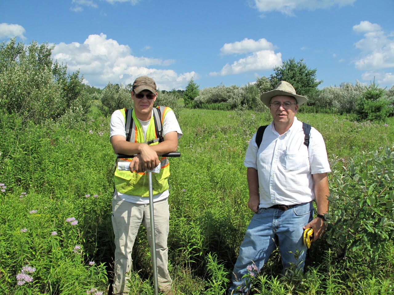
Pipeline Environmental Evaluation
Steve Finch and Stephen Caruana of Kleinfelder were in the neighborhood today conducting an environmental evaluation of the proposed Chesapeake gas pipeline.

21 July 2010
EASTHILL site survey
Greenway Engineering was in the neighborhood today to do the initial survey of the proposed EASTHILL (EAW37) drill site. This survey will be done with a GPS mapping system to create a 3D map of the property for use in creating a well pad layout. Two wooden survey stakes and metal pins were placed along Joyce Road next to our cabin property as reference markers for other surveys done on the EASTHILL drill site.


Subscribe to:
Posts (Atom)

